


Research
Human localization and mapping
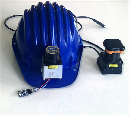
A laser scanner is mounted on a helmet (together with a 6-DOF Inertial Measurement Unit, IMU) to build a map-generation and self-localization application based on wearable sensors. The limitation due to the fact that the measurements are detected on the scanning plane is mitigated by the assumption that the relevant obstacles (which cannot be overcome) are the ones which are visible at a fixed height, e.g. the height of the head. The reliability of the measurement is instead crucial to reconstruct good maps even in complex environments. Also, being able to use the raw data from the sensor, without the need of pre-processing them to extract some distance information, reduces the computational load of the application.
The map is generated by adapting SLAM (Simultaneous Localization And Mapping) technologies, normally used in mobile robotics, so that they can be applied to the data gathered by wearable sensors. Further problems need to be faced: for instance, encoders are not available and they are replaced with an IMU, but IMUs are prone to drift. Moreover, the movements of the neck affect the laser measurements. A filtering technique based on Extended Kalman Filter (EKF), whick makes use of heuristics and operational hypotheses, is proposed.
Reference paper: Human navigation and mapping with a 6DOF IMU and a laser scanner, Marco Baglietto, Antonio Sgorbissa, Damiano Verda, Renato Zaccaria Robotics And Autonomous Systems (RAS), December 2011
![]()